 Index Index
Pearls on the Net
Features
Your Stories
Deutsche Ecke 
Beyond Skydiving
Treasure Chest
Featured Sites
News & Articles
Current News
Competitions
Boogies & Meets
Events & Courses
NSL News [USA]
SSI Pro Tour Safety Issues
Wanted!
World Weather
ShopZone
Newsletter
Skydive World
Greeting Cards
Skydive Forum
Skydive Books
Your Gallery
Contact
Archive
Guestbook


Web Design by
Netword-Project
© 2001 |
|
On this page we feature whatever you can think of or what you might suggest to us. These suggestions can be about people, teams, drop zones, software, books, videos, games, and...and... | More features on pages [1] [2]
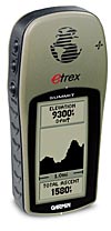
Garmin eTrex Summit
by Yuri Kuznetzov - http://base416.comGarmin eTrex Summit is a perfect tool to record your wingsuit (or any other) flight data. It combines GPS, barometric altimeter and electronic compass to provide you with a full and accurate 3D tracklog of your flight. The Summit specifications can be found at www.garmin.com/products/etrexsummit.
You can order Summit online for about $200, plus $20 for PC interface cable. You will need some PC software to analyze your flight data: the best I have found so far is OziExplorer. GPSTrack is supposed to work very well, but I haven't tried it yet. |
 |
First, check the version of your internal GPS software (System menu). Current version is 2.07, if you have 2.05 or less you MUST upgrade because of important bug fixes and a must-have satellite info screen. This upgrade program is self-explanatory:
www.garmin.com/products/etrexsummit/download.html
GPS will need a clear view of the sky all the time you want it to record. Summit saves your position and altitude once a second. Turn "Compass" off to save some battery. Also you can turn "Automatic Altitude Calibration" off and instead type in your DZ elevation (or something close enough) manually.
GPS gets the best signal mounted on the helmet (if you have a better idea where to put it, please let me know. I hate helmets! ;-) It has to get a good signal within a couple of minutes before the exit, and keep getting it until right before the exit (keep it by the window or next to the pilot). The signal can break for up to 30 sec (as you get ready and exit). GPS will keep a continuous track during that time. If a signal is lost for more than 30 sec, your track will be broken and you will loose some data around exit time.
Summit can save up to 20 tracks, however it will compress them and remove the time/date info. Use the "Current Track" only: if you turn GPS off between jumps it's big enough for 3 to 5 flights. Check the memory status: once it reaches 100% your earlier track data will be overwritten.
If you follow a plane after exit, it may be hard to figure an exact moment of your departure. Turn 90 off the jumprun to put an easy mark on your tracklog. Opening point is obvious.
To analyze your data you will need the following:
First, download OziExplorer from www.oziexplorer.com. Get the full version 3.85.4.3 and then the development version 3.85.6.2 (at the bottom of the page). Install the full version and then pun development files on top of it. It is important because 3.85.6.2 version has Track Profile (altitude chart) etc. added.
Download data from GPS. Select a blank map. Go to "View, Tracks, Track Control". There you will see saved tracks and "Active Log". Double-click on "Active Log", make sure you save it, then go back to "Track Control" and click on "Show Track List" icon. There you'll see a table with all data for your flight recorded at one second intervals. Highlight your entire flight or any part of it and use "Show Summary" icon ("E") to see all relevant info. Also you can go back to "Track Control" and use "More Options", "Track Profile" for elevation/speed profile. It is very visual, but less informative number-wise.
GPS Track software should draw a very nice 3D picture of a flight as well, but i didn't try it yet. It is free at www.gpstrack.com. Please let me know if you use and like it!
Special thanks to Jean-Noel, Robert and others for providing many useful tips. |
More features on pages [1] [2]
|
